
Overview
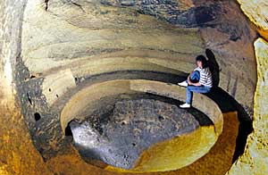
One of the few malt kiln caves that has survived intact.
The city of Nottingham stands on an outcrop of Triassic sandstone that forms low hills on the north side of the River Trent. The broadest of these hills was the site of the original Saxon settlement, and the higher but smaller hill just to its west was occupied as the Norman stronghold in the year 1068. The Norman town expanded until it occupied most of the sandstone outcrop immediately north of the low cliffs and bluffs that descend to the Trent floodplain, and the town grew little more in size until the mid 1800s.
Nottingham's Triassic sandstone, locally known as the Nottingham Castle Formation within the Sherwood Sandstone Group, is distinguished by its low intact strength and its high rock mass strength. The sandstone has a high porosity, from which an initial calcite cement has been leached beneath all outcrops, so that only a weak clay cement remains. And the rock is notably free of significant joints or major bedding planes. This fortuitous combination of a weak material and minimal structural breaks makes Nottingham's sandstone an ideal tunnelling medium; it is easily excavated and yet stands safely over an unsupported span.
This fact must have been appreciated by the early inhabitants of the region, who would have found it easy to create dwelling space by excavating into the foot of the sandstone cliffs along the edge of the Trent floodplain. Nottingham was documented as a "house of caves" by Asser, King Alfred's chronicler in the 9th century, but little more is known of these early cave houses. All have since been destroyed. Weathering causes cliff degradation and retreat, which has been matched by the townspeople cutting back the cliff profiles; new generations of caves were then excavated behind the position of those that had collapsed or had been removed when they became unstable.
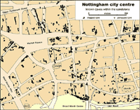
Map of Nottingham’s city centre with all the known caves marked. Click on the image for a larger-scale version.
More than 500 caves are known under the city of Nottingham, but all of these are thought to date from post-1200, while only a small proportion is post-1850. Practically all the available natural cliff faces had caves cut into them; some with multiple generations, but most of the caves were excavated underneath buildings, with stairway entrances and little or no natural light inside them. Most were effectively sub-basements under individual buildings, though some were dug out beneath the adjacent gardens or yards. Caves beneath buildings were generally dry, because the building itself prevented rainfall infiltration. Most caves are 2-6 m wide and about 2 m high, but could be as long as required or as dictated by the boundaries of the available land.
The main use for the caves was storage, especially for liquids, where the benefits of year-round constant temperature underground could be realised. Almost every inn and public house had its beer cellar carved out of the rock, with steps down from the bar and a vertical barrel-drop down from the backyard; many of these are still in use today.
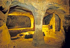
Pillar Cave, originally a tannery cave open to daylight at the front and now looking a little different beneath the Broad Marsh Centre.
Caves were also used as work places. These include the medieval malt-kiln caves that are unique to Nottingham, of which thirty have been discovered to date. Each consists of a small complex of caves that included a large germination room where the grain was prepared, the underground kiln where it was roasted, and a well as deep as necessary to reach the local water table. Also distinctive are the underground tanneries, with tanning pits cut into their rock floors; these have all been found in caves along the floodplain cliff, adjacent to the town's zone of 16th century tanneries that were mainly in the open and therefore of restricted use during freezing winters during the Little Ice Age of that period when average temperature were about 1ºC lower than they are today. Metal works, wagon works, monastic chapels, butchers, cisterns, ornamental follies, wine vaults and grocers' cold stores were among other uses for the caves, along with just a few access tunnels.
There were also at least three groups of mines, where sand was extracted. The largest of these was worked by James Rouse and colleagues for about 20 years around 1800, just to the west of the Mansfield Road in its rise to the Forest. This was a classic pillar-and-stall mine with a random pattern created by selective hand-working to take the cleaner and perhaps the softer sandstone. Breaking it out from the working faces caused it to disintegrate into sand, which was carried out of the mine on donkeys through a gently inclined drift. Another large sand mine has largely collapse, but remains of it can be seen in the city’s splendid Rock Cemetery.
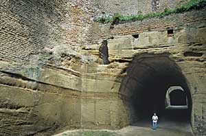
The Tunnel, originally excavated to take coaches-and-horses in both directions.
Only a handful of the caves are in use to-day. The remainder constitute a significant local geohazard with respect to urban re-development; larger buildings and heavier loads are now imposed upon ground that may be underlain caves excavated and designed centuries ago to be covered only by smaller and lighter structures. The sandstone weathers by breakdown of its weak clay cement. This is significant on exposed faces and also in caves open to circulating atmosphere, but is not a problem in caves that are virtually sealed behind doors or beneath houses. The most spectacular caves in Nottingham are those excavated for Alderman Herbert on the north side of the Park estate; the cave with the statues of Daniel in the Lions’ Den has recently had doors fitted to it to protect it from weathering damage. These caves are not accessible, as they lie beneath private houses, but the nearby Tunnel is an unusually large cave that is still a public footpath from Tunnel Road through to Upper College Street.
Progressive redevelopment in the city has caused many caves to be lost, because their entrances have been changed, while their inner rooms remain open and potentially unstable. The hazard along roads is created when the sandstone is saturated, for example by a leaking pipeline, so that it loses most of its modest strength and falls away from cave roofs in thin slabs. Appropriate ground investigation is therefore needed prior to all new construction in the inner city, which is carefully controlled with respect to rock loading over the caves. Remedial works commonly involve concrete filling, but some caves have heritage values that mean they have to be protected while suitable foundations are placed around them or straddling them.
The most useful source of information on the caves is the small book “Sandstone Caves of Nottingham”, written by Tony Waltham and published by the East Midlands Geological Society in 2008 (Third Edition), with 56 pages of text, photographs and maps, available from book shops, the tourist cave shops or through www.emgs.org.uk .
Structural
- Caves accessible with guided tours for visitors are the ‘City of Caves’ beneath the Broad Marsh Shopping Centre, and Mortimer’s Hole under Nottingham Castle
- Some public houses allow some access to their old beer cellar caves, including the Salutation Inn on Maid Marion Way
- Parts of the old mines in the Rock Cemetery on Mansfield Road can be viewed by anyone.
The Tunnel is open on Tunnel Road, The Park - Rouse’s sand mine is currently not accessible.
Cartographic
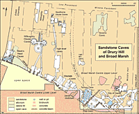
Map of the caves beneath the Broad Marsh Centre, with those that are open to visitors as “City of Caves”, and the caves further west that are not currently accessible. Click on the image for a larger-scale version.
Numerous maps of caves are displayed in the book “Sandstone Caves of Nottingham” by Tony Waltham (see right).
Graphic
Photographic
Numerous photographs of caves are displayed in the book “Sandstone Caves of Nottingham” by Tony Waltham.
Old photographs of Nottingham caves are available on the Picture the Past website.
Artistic
Nottingham Castle Museum and Art Gallery
- English School, Nineteenth Century: View of Nottingham Castle and Rock, looking east; View of Rock holes in the Park, Nottingham
- T C Hind: View of the Rock cavern in Nottingham park
- John Rawson Walker: Entrance to Mortimer’s hole, Castle Rock, Nottingham.
Drawings of caves are published in:
- The Stretton Manuscripts: being notes on the history of Nottinghamshire, by William Stretton (1910)
- Arthur Stapleton, An Historical Sketch of the Caves of Old Nottingham and The Nottinghamshire Coalfield: some notes regarding its ancient history (1904)
Archival/written
Nottinghamshire Archives
- Rock caves and cellars in Nottingham (1954) [CATC 10/129/169]
- Cellars [ DDEM 21/1; DD600/9; DD683/20]
- Rough cave dwellings near Nottingham with ground plan of caves [X/PR/9/19]
Printed
The key references on the caves are:
- Waltham, T., 2018. Sandstone Caves of Nottingham. Fourth Edition, East Midlands Geological Society: Nottingham, 56 pages.
- Hamilton, A., 2004. Nottingham’s Caves. Second Edition, Nottingham Civic Society: Nottingham, 40 pages.
Owen, J.F. & Walsby, J.C., 1989. A register of Nottingham's caves. British Geological Survey Technical Report, WA/89/27. - MacCormick, A., 2001. Nottingham's underground maltings and other medieval caves: architecture and dating. Transactions of the Thoroton Society of Nottinghamshire, volume 105, pages 73-99.
A short list of all significant publications on the caves is available as:
- Waltham, T., 2008. Bibliography of Nottingham’s caves. Mercian Geologist, volume 17, page 68.
See also www.emgs.org.uk/local for various items about the caves.
![]()