
 |
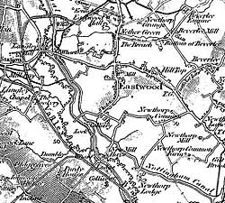
Extract from the Ordnance Survey 1" to the mile map depicting landscape features (railways, canals, relief etc) around Eastwood. |
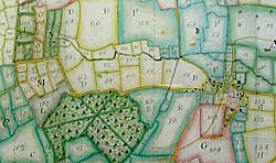 |
Extract from manuscript estate map of Winkburn dating from 1766, showing fields, woods, roads, village layout. |
Cartographic
- C Delano-Smith & R Kain, English Maps, Brit Lib., 1999
- S. Bendall, Dictionary of Land Surveyors and Local Mapmakers, 2 vols, British Library, 1997]
Printed
- County and urban maps, 1576-1820s (Nottinghamshire Local Studies Library; Nottinghamshire Archives Office; British Library) [see TTS, 34]
- Facsimiles of county maps: Saxton (1576): British Library; Speed (1610): The Counties of England; Ogilvy (1675):
- Facsimiles of maps of Nottingham: Nottingham Civic Society
- OS maps, 1840s > (Nottinghamshire Local Studies Library; Nottinghamshire Archives Office; BL) [see Y. Hodson, Popular Maps, Chas. Close Soc., 1999]
- G. Sanderson, Map of the country twenty miles around Mansfield, 1835 (reprinted, 2001)
- Nottinghamshire Historic Landscape Characterisation project, - carried out between Feb 1998 and Sept 1999 by Notts. County Council's Environment Dept in partnership with English Heritage and a report is being completed.
Manuscript
- 14thC - 19thC (PRO; British Library; Nottinghamshire Archives Office, PRO) [see H. Nichols, Local Maps of Nottinghamshire, 1987 and W. Foot, Maps for Family History, PRO, 1994]
- S.Mastoris & S Groves, Sherwood Forest in 1609, (TSRS 40) [for maps of land in Sherwood Forest]