
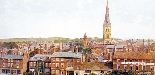
View over Newark from the castle, c.1910.
Overview
Newark’s importance derives from its location at the intersection of major communication routes: the River Trent, the Roman Fosse Way and the Great North Road. Newark became a substantial inland port, particularly for the wool trade, and later its position on main roads encouraged the development of inns and hostelries to sustain the many travellers passing through the town. The arrival of the railways in the 1840s gave further stimulus to Newark’s economic growth.
The early history of Newark is stubbornly elusive. Remains of Roman settlement have been identified at Northgate, near the road bridge over the East Coast railway line and a considerable amount of Roman pottery was found during the excavations at the castle during the 1990s. However, the full size and character of the settlement remains unknown.
A large pagan Anglo-Saxon cemetery has been uncovered in Millgate and a Christian cemetery dating from c.950 to c.1070 was discovered at the castle. It has traditionally been assumed that the Saxon borough probably occupied the area of the later Medieval town as defined by the defences following the rectangle of streets (Lombard Street, Carter Gate and Appleton Gate, Slaughter House Lane and the west side of Castle Gate). However, excavations on the defences in the 1970s found no trace of Saxon activity and the archaeologists concluded that the Saxon borough occupied a much smaller area within the town.
Medieval Newark
Newerche is not referred to as a borough in Domesday Book but 56 burgesses, 42 villagers and 4 smallholders and 7 free men are recorded; the Bishop of Lincoln was lord of the manor. The name means ‘new work’ to distinguish it from an unidentified defended site known as ‘The Aldwark’ in 1316. The ‘Aldwark’ could well be one of the Romano-British defended settlements such as Thorpe or Brough or even the North Gate site in Newark itself.
The first castle was built shortly after the Norman conquest, possibly after the ‘Harrying of the North’ in the winter of 1068-9. Excavations on the town rampart in Slaughter House Lane suggest that the rampart is contemporary with the castle so the evidence points to Newark having been developed as a planned town by the Normans, incorporating the existing but smaller Saxon settlement within it.
Charters dating from the 1130s record Henry I’s permission to build the castle, divert the King’s Highway (now Castle Gate), to build a bridge over the Trent, and to establish a five-day fair “at the castle”. Bishop Alexander founded the hospital of St. Leonard at the same time and it is possible the defensive circuit was extended. A survey of 1225-31 reveals that the town had by then extended beyond its defences, and suburbs had grown up along all the roads approaching the town.
The borough was incorporated on 21st December, 1549. The town had a population of around 2,700 and derived its wealth from trade in wool, hides and leather, cloth manufacture, the traffic in coal and other commodities on the River Trent and business brought by the growing use of the Great North Road (a route developed during the middle ages that crossed the Trent at Newark). It has also been argued that Newark also benefited from its pre-Conquest soke: its court met every three weeks which, with the twice-yearly wapentake court and weekly market, “helped to build and maintain Newark’s importance”.
17th-18th centuries
The Civil War (1642-1646) was without doubt the most dramatic period in Newark’s history. The town’s geographic location was again important as it controlled the Trent crossing that linked York and the north with London and King Charles’ headquarters at Oxford. The town stood solidly behind the King and withstood three violent sieges in 1643, 1644 and 1646. The inhabitants suffered greatly: apart from deaths resulting from the conflict typhus spread through the population between 1643-1645 and plague broke out in 1646. Both diseases probably killed more people than the fighting.
The siege of 1646 lasted six months and, following Charles’ surrender to the Scots at Southwell on 5th May, ended with the capitulation of the Royalist garrison.
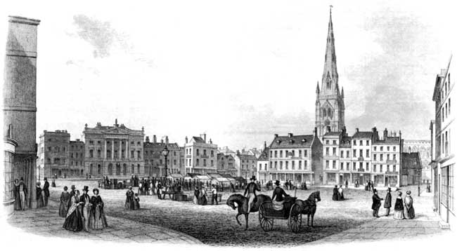
A view of the Market Place in Newark, c.1850.
By 1801 Newark had a population of 6,730 and was the county’s second town. Road traffic between Scotland and the north and London used the Great North Road so coaching inns such as the Ram and Saracen’s Head were not short of business. The weekly market and six annual fairs underpinned Newark’s wealth which was reflected by the rebuilding of the Market Place in the 18th century with coaching inns, houses of leading citizens and the splendid new Town Hall (1773) by John Carr. Georgian Newark was considered to be elegant and well-built. It was also fashionable, with a rich cultural life: a theatre was established in 1774 and a large bowling green laid out in the castle grounds.
Industrial development
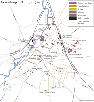 Map of Newark, c.1920 (click on the image to view a larger version of the map).
River traffic grew in quantity during the 18th century but it was not until the 1772 Act to improve the Trent that locks were built at Newark thus ensuring it became a busy inland port with warehousing, boat building and wharfages based around the Town Lock.
The two railway routes arrived in 1846 (Great Northern Railway) and 1852 (Midland Railway) and gave the town considerable economic stimulus. Coach traffic, however, was adversley affected and dramatically declined.
Principal industries in the late 19th century were malting and brewing, engineering (in particular the manufacture of agricultural machinery, boilers and industrial hardware), flour milling, tanning and textiles. Newark’s prosperity during this period is embodied in the fine Victorian buildings around the town: The Corn Exchange (1847-8), the Gilstrap Free Library (1883) and the Ossington Coffee Palace (1882).
By the early 20th century Newark benefited from the establishment of two engineering companies, Worthington-Simpson and Ransome and Marles. The strong foothold in engineering and the arrival of new industrial activities such as sugar-refining helped to lessen the effect of the decline in malting and brewing.