
Cartographic
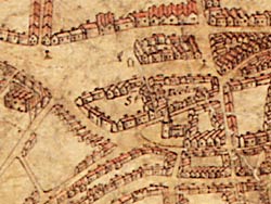
Extract from John Bankes' Survey of Sherwood Forest (1609) depicting the market place with St Peter's church to the south.
Printed
The earliest maps of the town have been printed, and copies can be consulted in the Local Studies Library:
- John Speed (1610)
- Map of Nottingham published in Robert Thoroton, The Antiquities of Nottinghamshire (1677)
- John Badder and Thomas Peat, A plan of the town of Nottingham from an accurate survey...with a View of the Town, and Views of the principal buildings, engraved by Thomas Basire, (1744)
- William Stretton, Nottingham (1800)
- H. Wild and T H Smith, A New Plan of the Town of Nottingham (1820)
- E Staveley and H M Wood, (1831)
- William Dearden, Plan of the Town of Nottingham from the best Authorities Containing all the new Streets and every recent alteration (1844)
- H. M. Wood, ... Plan of Nottingham ... (1848)
- E.W. Salmon, Plan of the town of Nottingham and its environs (1861)
- Frederick Jackson, Plan of the Town and the County of the Town of Nottingham ... (1861)
- Frederick Jackson, ... Plan ... of Nottingham ... (1866)
- M. O. Tarbotton, Plan of the Borough of Nottingham 1878 (1984)
- J. Hunt, Nottingham enclosure map (photocopy) (1865)
Also useful are the Ordnance Survey maps 1881, 1901, 1915 (large scale), and subsequent editions through the 20th century.
The 1609 map by Richard Bankes is reproduced in:
- S.N. Mastoris and S.M. Groves, eds., Sherwood Forest in 1609 (Thoroton Society, Record Series, XL, 1997)
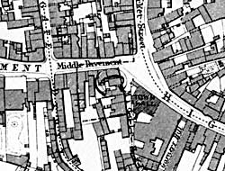
Extract from Edward Salmon's Plan of the town of Nottingham and its environs, published in 1861, showing the area around Weekday Cross.
Maps from the 1670s to the beginnings of the Ordnance Survey series, have been published by the Nottingham Civic Society, and are available through the county library services. Similarly, maps for a wider area around Nottingham are also available in recent publications, including John Chapman (1774) and Sanderson (1835).
Large scale OS maps (at scales of 1:2500 and 1:500) from the late 19th and early 20th centuries show the town in great detail, and some have been reprinted by Alan Godfrey Maps in recent years and are available in local libraries and in bookshops:
- Alan Godfrey Maps, Old Ordnance Survey maps: Central Nottingham 1899 (1997)
- Alan Godfrey Maps, Old Ordnance Survey maps: Nottingham (South) 1899 (1997)
- Alan Godfrey Maps, Old Ordnance Survey maps: Nottingham (North) 1913 (2003)
Manuscript
One of the best sources of cartographical evidence are contained in the late nineteenth and early twentieth century large scale Goad insurance maps available in the Nottinghamshire Archives Office. Volumes I-III of the Goad maps have been digitised and are available on the British Library website: