
 |
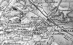
1 inch Ordnance Survey map of Southwell (c.1883). |
Cartographic
Printed
George Sanderson’s Map of the country twenty miles around Mansfield, originally published in 1835 at a scale of 2¼ inches to 1 mile is the earliest printed map depicting Southwell at a reasonably useful scale. A facsimile version has recently been produced by Nottinghamshire and Derbyshire Library Services:
- George Sanderson, Twenty miles around Mansfield, 1835 (Reprinted by Derbyshire and Nottinghamshire County Councils, 2001)
A wide range of Ordnance Survey maps from the 1840s to the present day are available at Nottinghamshire Local Studies Libraries and Nottinghamshire Archives. The earliest large scale (6” to the mile) coverage dates from the 1880s and an online digital archive of this map series for the whole country is accessible through the Old Maps website:
Larger scale Ordnance Survey maps (at scales of 1:2500 and 1:500) from the late 19th and 20th centuries show the town and its features in great detail.
Manuscript
- A mappe of Norwoode Parke … 1649 [Borthwick Institute, York: CC.Ab.11.90 S]
- South Park, surveyed 1683 [Nottinghamshire Archives: SO 10 S]
- Southwell open fields surveyed by V J Fish, 1760s [Nottinghamshire Archives: SO 1-5 L]
- A plan of Cottmoor and all that part of Radley within the district of Southwell as it was divided by order of the Commissioners of the said commons, AD 1775. Thomas Nelson, surveyor. [Nottinghamshire Archives: EA 40 / The National Archives MP LL 4 (1)]
- Plan of Normanton … 1775. Thomas Nelson, surveyor. [Nottinghamshire Archives: EA 27 / The National Archives MP LL 4 (3)]
- A map of the new road over Palmer Yard in Easthorpe and the lanes given to Sir Richard Sutton, Bart in exchange for the New Road, 1780 [Nottinghamshire Archives: SO 8 S]
- Survey and maps of lands, in the Liberties of Southwell and Halam … the property of Richd. Stenton Esqr. 1784 by W. Attenburrow Junr. [Nottinghamshire Archives: DD M 102/16