
Tollerton, Nottinghamshire, not to be confused with the one in Yorkshire, was mentioned in the Domesday Book in 1086 where it was spelled Troclaveston suggesting that the name of a person is incorporated in the village name. The word tun being a farmstead. There are various ideas about this but Thorlagh or Thorlaf’s farmstead seems to be the most obvious. According to Potter’s 1929 history1 and Place names of Nottinghamshire the name has had many variations and has ‘suffered a great deal of corruption’ throughout the 13th and 14th centuries but the 16th century Tollarton is the closest to the present day name of the village which is situated just off the A606 Nottingham to Melton Mowbray road and close to Plumtree, Nottinghamshire. It is still classed as a village although there is a distinct split between the original village with the church and manor house and the later 20th century built houses which occupy an area adjacent to the A606.
There is an aerial photograph which shows a moated structure in a field behind Chestnut Farm on Cotgrave Lane but how old this is is not known and there has been no archeological work on this site. The landscape of the village is mainly flat but there are two elevations; one around Jubilee Wood at the back of Little Lane and the other towards the A606 end of the village. Other features such as Tollerton brook, which runs under Cotgrave Lane and feeds the Lake in the Hall grounds, which was constructed sometime in the 18th century.
Tollerton was described in the 19th century as a picturesque village, four and half miles south east of Nottingham sitting on a slight rise above the surrounding area. The area covers about 1200 acres most of which is arable farmland. Potter said the village had never been a place of importance or had a large population. For the 19th century and early 20th century the population fluctuated around 150 persons, which was split roughly half and half between male and female. The population prior to these dates gives similar figures corresponding to outside factors such as the Black Death. The more recent development of the village near to the A606 is an overspill from Nottingham and its environs; the population in 1965 was 1550 with 500 homes, 98% being owner-occupier by 2010 the population had grown by just over 250 to 1,776. Unlike its near neighbours, Plumtree and Edwalton, Tollerton did not have a railway station although the main Nottingham/London line ran on the opposite side of the A606 to the village. The line closed in the 1960s but the section from Widmerpool to Edwalton was used as the Old Dalby test track. The Grantham Canal (1797-1930) skirts Tollerton at its most northerly point.
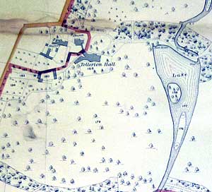
Extract from 19th century map of the Hall and park.
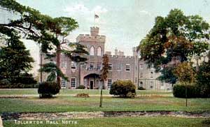
The main families who have owned the South Manor house are the Barrys, Pendocks, Neales, Broadhursts and Burnsides. The Barry family was the original occupiers of the village manor, but with the failure to produce male heirs from the Barry family, the daughter of Thomas Barry, Matilda married Richard Pendock and the family became known as Pendock Barry. The last family to own Tollerton and live in the Hall was William Elliott Burnside and his wife Alice Mary Burnside. It is believed they purchased the estate in 1908. William also owned Plumtree. When he died in 1911 his wife remained at Tollerton Manor for some years before her death in Middlesex in 1927. The Estate was sold to a consortium which included Sir Albert Ball father of the flying ace, who became lord of the manor and principal landowner. By the late 1930s land close to the A606 began to be sold off in plots for house building. Some housing was built between the wars along the A606 and along Tollerton Lane. OS maps show that most of the constructions of homes adjacent to the A606 were built post-1945. Homes were built up to a level with Priory Avenue but farm land beyond that was not used until the late 1950s/60s.
The village came under the wapentake or hundred and union of Bingham. It had been enclosed in 1804 but Thoroton claims that Philip Pendock had made an extensive enclosure in the latter part of the 17th century; by the Enclosure act 1803 half the Parish was enclosed. In terms of whether it was an ‘open’ or ‘closed’ village it is probably classed as a ‘closed’ village with only one major landowner until the 20th century.
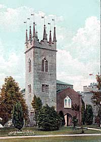
St Peter's church, Tollerton in 1905.
In 1869 it was recorded as being in the No 3 Deanery of Bingham, archdeaconry of Nottingham, diocese of Lincoln, hundred of Bingham, South Nottinghamshire. In 1881 it was recorded as being in the West Bingham rural deanery, Nottinghamshire archdeaconry and Lincoln diocese, but by 1885 the diocese had changed to Southwell.2 Today the village is part of Rushcliffe Borough Council district.
| Year | Total Population |
| 1801 | 176 |
| 1811 | 142 |
| 1821 | 153 |
| 1831 | 149 |
| 1841 | 155 |
| 1851 | 157 |
| 1881 | 124 |
| 1891 | 123 |
| 1901 | 156 |
| 1911 | 169 |
| 1921 | 140 |
| 1931 | 127 |
| 1951 | 893 |
| 1961 | 1,207 |
| 1971 | 1,682 |
| 1981 | 1,791 |
| 1991 | 1,727 |
| 2001 | 1,723 |
Source: www.visionofbritain.org.uk
The crossroads, which is roughly where Tollerton Lane, Cotgrave Lane and Little Lane converge, is believed to be where village life began. Soon after the time of the Norman Survey the manor was divided into two. Two manors almost of necessity imply that there were two manor houses or halls. The North Manor House is believed to have been built close to what is now Chestnut Farm on the north side of Cotgrave Lane. There was a mill situated in this area, possibly because of the accessibility to water from either the moat or the river Thurbeck; more a stream than a river, (see Sanderson’s map of 1835). There is evidence of a weir close to Cotgrave Lane where the river runs underneath the road. The South Manor House was subsequently built near to the church in the 11th century by the Barry family. It can be pinpointed from 1674 when Philip Pendock paid Hearth Tax on fourteen chimneys. Deering, in his History of Nottingham, 1751, commented on it being a pleasant house, altered and improved by John Neale.
The main occupation for Tollerton was farming and this is reflected in the number of farms which could be found in the village. All of them apart from Russells Farm were located in and around the old part of the village. Chestnut Farm, at the crossroads of Tollerton Lane and Cotgrave Lane; Manor Farm opposite Tollerton Hall; Glebe Farm slightly south of this; Hall Farm at the top of the hill on Tollerton Lane and Russells farm on Burnside Grove. For many years arable farming was predominant but due to post-1875 Agricultural depression the extension of pasture farming led to a decline in arable and thus a reduction in labourers. In more recent times cattle and pigs have been farmed in the village but once again much of the land has been returned to arable farming. In more recent times all apart from Glebe Farm and the pig farm situated adjacent to Glebe Farm, the farms have been sold off and the buildings have been converted into new housing. The farm land is now contracted out to other farmers for arable farming.
The village has never had any industry, apart from a few units housed at Tollerton Airfield and some light industrial units housed off Lothian Road which have now been replaced by housing. Muir’s garage, a family run business, situated on the corner of Tollerton Lane, was closed in the 1990s and was replaced by a petrol station.
There appears not to have been an inn in the village since 1686 when it had one with a bedroom and stabling for 2 horses. An application for a license in the 19th century was refused. In 1964 a public house was built at the top of Stanstead Avenue where it joins Burnside Grove. The long since gone Home Brewery owned the The Air Hostess (so called, because of its closeness to what is now East Midlands Airport and nothing to do with the Tollerton airfield) and the pub has survived the downturn in use and was well patronized in 2011.
Although there is no trace of them today the village had two mills. Tollerton offered equal facilities for wind and water mills, having high ground close to the village and a brook almost as near. In Throsby’s picture of Tollerton hall 1792, a windmill can be seen close to the Hall and the lake. Two fields to the north of the village adjacent to Tollerton lane were named Mill Wong which indicates a mill in the neighborhood. In 1683 a document, mention is made of a windmill in Hallbriggfield which is closer to Chestnut farm. On the Tollerton manorial demesne map of the 17th century there is a windmill clearly marked in a field marked Hallbridge which maybe where Jubilee Wood and Near Mill are located in the 19th century map. Throsby’s sketch clearly shows a windmill situated at the rear of Tollerton Hall. A family named Hickling worked one of the mills for some generations until it was burnt down in 1810.
Education in Tollerton was rudimentary. In the 18th century it was in the hands of the parish clerk, a man named John Hooley and when he died his burial is recorded in 1777 as John Hooley, Schoolmaster. Children were taught in the Church until Pendock Neale’s son made provision for schooling when he built the ‘Town End’ cottages at the exit of the village on Tollerton Lane and circa 1833-1847, added a room over the arch way for schooling and the cottage south of the archway for the teacher’s dwelling. The school was closed at the end of the 19th century and children attended Plumtree School. For a period there was a private school on Tollerton Lane during the 1950s. Eventually in September 1959 a council primary school on Burnside Grove was opened.
There has been a Post Office in the village since the beginning of the 20th century and was situated in a house opposite Bassingfield farm. Prior to that Plumtree was the nearest P.O. In the 1930s the Post Office was moved to the gateway lodge on Cotgrave Lane but now is situated on Melton Road (Mace). This shop has over time sold wool and fish and chips. In the 1940s, where the Chinese restaurant was in 2011, a greengrocer, Andersons and a butcher Pritchards were situated. In the 1950s these shops were taken over by the Co-op and turned into a small supermarket. During the late 1960s a row of shops including a butcher, greengrocer, supermarket and hairdresser were opened on Burnside Grove but with the opening of large chain supermarkets in the vicinity they closed down and the hairdresser was the only one to remain of those original shops in 2011.
Leisure facilities in the village have come and gone. In the 1950s and ‘60s there were an active Tennis and Cricket club situated on land on Cotgrave Lane, neither of which exist today. Land belonging to Russell’s Farm was purchased on Lothian Road and an ‘Open Space’ with children’s playground, two tennis courts and football pitch was built in the 1980s.
There was a very active Women’s Institute in the village which celebrated its 25th anniversary in 1965, with a scrapbook now housed at the Nottinghamshire Archives. As the age group in the village has changed so have attitudes and the WI closed in 2008.
There are no Almshouses in the village but there is mention of a Charity left at the bequest of Agnes Crosse, sister of a Rector at Tollerton, in 1722, leaving 50shillings a year for the poor.
St Peters Church is the Anglican church of the village – see Structural section. The Methodist Hall on Stanstead Avenue has been there since November 14 1964 when the previous chapel at Normanton on the Wolds was closed down.
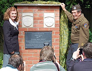
The unveiling of the memorial to the 507th US Parachute Infantry Regiment in 2013.
On Saturday 1 June 2013 a memorial to the 507th US Parachute Infantry Regiment, who were billeted at Tollerton Hall in March 1944, was unveiled by the last remaining member of the division, Roland Daniel, aged 90 years, and the daughter of Edwin Ostberg who was the commander of the division but was later killed in action. The memorial is located next to the village War Memorial.
References
1. S P Potter, History of Tollerton, (Nottingham, 1929) is the only known written history of Tollerton.
2. "Until 1837 the archdeaconry of Nottingham formed part of the diocese of York. Between 1837 and 1884 it was part of the diocese of Lincoln. The diocese of Southwell was formed in 1884 from the diocese of Lincoln and included Derbyshire until Derby was made into a see in 1927."
![]()
![]()