
 |
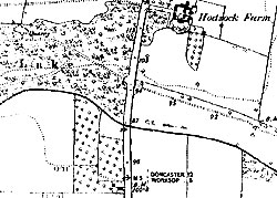
Detail from a late 19th century Ordnance Survey map at a scale of 6" to the mile. The area around Hodsock Farm (south of Blyth) is shown. |
Cartographic
Printed
Nottinghamshire Archives and the Nottinghamshire Local Studies Library together hold a collection of maps. Ordnance Survey maps form the bulk of the collection, which gives coverage of the whole county at all scales and, with some exceptions, at all dates published. (Earliest between 1824-1836).
Manuscript
Estate maps are a critical source which often give information about farming systems. A listing of those available and where they are to be found is in
- Harold Nichols, Local Maps of Nottinghamshire to 1800: an Inventory (1987)
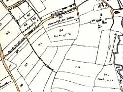 |
Detail from the enclosure map for Basford, dating from 1790. |
Also important for understanding farming systems and agricultural change are enclosure maps, and tithe maps. These can be found in Nottinghamshire Archives for many villages across the county. For brief introductions to their usage see
- S. Hollowell, Enclosure Records for Historians (2000)
and
- Roger Kain and Hugh Prince, Tithe Surveys for Historians (2000)
N.B. also the importance of enclosure and tithe maps for the study of agriculture, and maps prepared for the whole country in 1910 in conjunction with the Finance Act of that year, and now housed in the Public Record Office:
- Enclosure Maps: search the PRO’s online catalogue under the place name you are interested in: http://catalogue.pro.gov.uk/
- Tithe Maps: Public Record Office, IR 51
- 1910 Survey: Public Record Office, IR 121-35 (and the Field Books in IR 58)