
Cartographic
Ordnance Survey
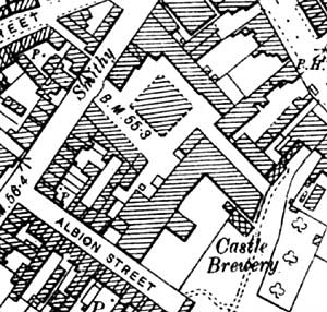
Castle Brewery, Newark-on-Trent on the 25" to the mile Ordnance Survey map of 1900.
Large scale Ordnance Survey maps from the late 19th century to the present day show brewery sites in great detail:
- 1:2500 (25” to the mile) and 1:10560 (6” to the mile) published in 1884 (1st revision in 1898; 2nd revision in 1916)
- 1:500 (10 feet to the mile) published 1882
Two online sources of historical Ordnance Survey maps of Nottinghamshire are:
Goad Insurance Maps
Charles E. Goad was a London-based firm of surveyors who mapped the major towns and cities to help fire insurance companies assess potential liabilities. The maps were produced at a scale of 1" to 40 feet and Nottinghamshire Archives hold maps for Nottingham for 1886-93, 1922, 1934, 1946 and 1962.
Building plans
Bassetlaw Museum hold two 1875 plans of the Worskop and Retford Brewing Company's brewery on Priorswell Road, Worksop.