
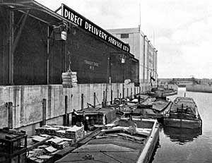
Loading barges at the Direct Delivery Ltd. warehouse in Nottingham, c.1939.
The roads of late-18th century England were inadequate for the transport of heavy or bulky goods such as coal and ore. Indeed, it has been said that “if Britain had had to depend on her roads to carry her heavy goods traffic the effective impact of the industrial revolution might well have been delayed until the railway age.” However, the navigable waterways offered an alternative means of transport.
Unfortunately, suitable waterways were rarely located conveniently near to the place of production so the solution was to construct ‘deadwater’ cuts or canals that linked the producers to the consumers. Canals had been constructed in England before this period, but the canal era is considered to have started with the construction of the Duke of Bridgwater’s Mersey and Irwell Canal, engineered by James Brindley and completed in 1761.
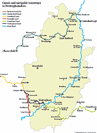
Map of canals and navigable waterways in Nottinghamshire (click on the map graphic for a larger version).
Although the canal age in Britain lasted about 80 years Nottinghamshire’s canals were constructed during the period 1771-1797. Navigable waterways like the River Trent became the backbone of the canal network and linked the Nottinghamshire canals to the rest of the country.
The canals were profitable enterprises until the coming of the railways in the 1840s. Railways could transport heavy goods in larger quantities and a greater speed and over time the railway companies took ownership of most of the canals and waterways in Nottinghamshire (the exceptions being the Erewash Canal and the Trent Navigation) and a period of slow but gradual decline followed.
Most of the canal and inland waterway system was nationalised in 1948 and under the Transport Act of 1962 the canals were transferred to the British Waterways Board (now British Waterways). Competition from road freight dramatically reduced commercial traffic on the canals and by the 1960s most of the county’s canals had been formerly abandoned. However, a growing interest in cruising on the waterways has since led to the restoration of the Chesterfield and Erewash canals by volunteers. Work continues on the Grantham Canal to restore it to full navigation.
The Chesterfield Canal
The Chesterfield Canal was the first canal to be built in Nottinghamshire and was promoted by the London Lead Company, looking for a shipping place for the lead from their smelt mill at Ashover, and the Cavendish family who wanted it to serve their furnace and forge at Staveley. James Brindley was commissioned to make a survey in 1769 and his proposed route from Chesterfield to West Stockwith via Retford and Worksop was accepted. The canal act was passed in March 1771 and work started later in the year. The full length of the canal (45.5 miles/75 km) with its 65 locks and two tunnels was opened on 4 June 1777.
Coal was the most important commodity carried on the canal and it travelled in the direction of the River Trent; other goods carried in the same direction included iron, stone and lead. Goods carried in the other direction were grain, foodstuffs, malt, timber and lime. The canal was also used to transport the building stone for the Palace of Westminster from a quarry near Rotherham.
Despite a short-lived boom in trade after being taken over by a railway company, the canal saw a steady decline in business after 1850: tonnage carried in 1856 was 118,946 tons but by 1905 this had reduced to 45,946 tons. To add to the canal’s problems the Norwood tunnel collapsed in 1908 which left the stretch between the tunnel and Chesterfield isolated. Ownership of the canal passed to the London and North Eastern Railway in 1923 and some maintenance work was carried out but by the mid-1950s all commercial traffic had ceased and the canal was abandoned. However, in 1962 a campaign was launched to re-open the canal for pleasure craft. Volunteer working parties have since then re-opened much of the canal.
The Erewash Canal
The canal was promoted by colliery owners along the Erewash valley keen to transport their coal to the River Trent and on to Nottingham to undercut the price of the coal in the town produced by collieries nearer to it. The canal obtained its act of parliament in 1777, with John Varley appointed as engineer and John and James Pinkerton the main contractors. The 11-mile (19km) canal runs from Trent Lock near Sawley to Langley Mill and was completed by July 1779 at a cost of £21,000.
The Erewash Canal was unusual in that it was never taken over by a railway company. However, by the mid-19th century trade was declining steadily and fell into disuse by 1952. Since then, enthusiasts have restored the canal for use by pleasure craft.
The Cromford Canal
The Cromford Canal was originally promoted as an extension of the Erewash Canal from the Langley Mill Basin to Pinxton to facilitate access to the under-developed coal seams in the area. It was also intended to serve the Butterley and Somercotes iron furnaces, Crich limestone quarries and Richard Arkwright’s cotton mills at Cromford. The 14½-mile canal was engineered by William Jessop and ran from the wharf in Mill Lane, Cromford to link with the Erewash Canal at Langley Mill, with a branch line to Pinxton. It was opened in August 1794 but the collapse of the Butterley Tunnel in the early 20th century split the canal in two. Although trade continued along the Langley Mill to Butterley stretch for some years the canal was finally abandoned in 1962.
The Nottingham Canal
The Nottingham Canal was promoted under an Act of 1792, and designed to help colliery owners near Nottingham compete with the Erewash Canal. The 14-mile (24 km) canal also started at Langley Mill and terminated at the River Trent but took a more direct route across the county and joined the river at Nottingham. The first phase of building covered the stretch between the wharves at Nottingham to the River Trent was completed in July 1793 but the rest of the canal was not opened until April 1796.
The most important traffic on the canal was coal; other goods carried were gravel, road stone and manure. The canal was taken over by the Ambergate, Nottingham, Boston, and East Junction Railway in 1855 and traffic steadily declined. It was disused by 1928 and finally abandoned in 1937, except for the 2¼ mile (3.6 km) section that ran from Lenton Chain to the River Trent through the city centre which was transferred to the River Trent Navigation and is still in use today.
The Grantham Canal
The last major waterway to be built in Nottinghamshire was the Grantham Canal. Construction started in 1793 and the canal opened in 1797. It was 33 miles in length and was built primarily to allow for the transportation of coal from Nottinghamshire collieries to Grantham. Its profitability steadily increased until 1841 and it was sold to a railway company in 1854. Traffic on the canal declined after this date and it was finally closed in 1936.
The River Trent and Beeston Canal/Beeston Cut
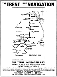
Advert for The Trent Navigation Company, c.1939.
Although the River Trent had been used for navigation for centuries it was not until the late 18th century that improvements were made. An Act of 1772 allowed the construction of a lock and weir at Newark on the eastern channel which runs through the town.
The Trent Navigation Company was formed by an Act of 1783 with the responsibility of maintaining and improving the river from Shardlow in Derbyshire to Gainsborough (Lincolnshire). William Jessop was appointed as permanent engineer.
An Act of 1794 authorised a lock and flood lock at Holme Pierrepont and also allowed for the construction of the Beeston Canal (also known as the Beeston Cut), a cut 2¼ miles (3.2 km) in length, which ran from the Nottingham Canal at Lenton to the River Trent at Beeston. It opened in 1796 and allowed boats to travel through the town and therby avoid hazardous conditions on the River Trent between Beeston Lock and West Bridgford.
After a period of decline, partly the result of the impact of the railways, an Act of 1906 was passed that allowed the construction of locks and weirs at Cromwell, Newark, Hazelford (near Bleasby), Gunthorpe, Stoke Bardolph and Holme Pierrepont.
The Trent has a long history as a navigable waterway and it “formed the backbone of the county’s waterway system” and survived after the canals had been officially abandoned.