
Cartographic
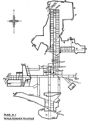 |
Plan of underground workings at Harworth Colliery. |
Colliery maps and plans
The Coal Authority's Mining Records Office in Mansfield has plans of abandoned underground mines since the 1872 Act which enforced the mine owners to submit plans of their abandoned mines to the government. They show the extent of both open and deep mining in England, Scotland and Wales (with over 120,000 plans). There are 4,700 plans for Nottinghamshire. They are kept for safety reasons and also for any future mining. These days they are used when new building developments take place, e.g. new homes and shopping complexes.
There are also around 100 surface plans for pits in Nottinghamshire which show what the colliery looked like when it was in operation.
These are all digitalized and can be inspected on request by applying to the:
The Mining Records Office
The Coal Authority
200 Lichfield Lane
Mansfield
Nottinghamshire
NG18 4RG
Tel. 01623 637 235
Web: coal.decc.gov.uk/en/coal/cms/services/records/records.aspx
Ordnance Survey
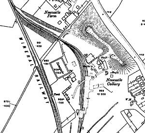 |
Newcastle Colliery, Whitemoor as depicted on the 25" to 1 mile Ordnance Survey of 1913. |
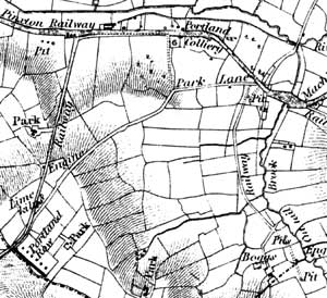 |
Extract from Sanderson's map of 20 miles round Mansfield (1835) showing Portland Colliery and the mineral railway network near Kirkby-in-Ashfield. |
Large scale Ordnance Survey maps from the late 19th and early 20th centuries show collieries and the landscape features around them in great detail:
- 1:2500 (25” to the mile) and 1:10560 (6” to the mile) published in 1884 (1st revision in 1898; 2nd revision in 1916)
- 1:500 (10 feet to the mile) published 1884, cover urban areas only
Consult copies at Local Studies Libraries and Nottinghamshire Archives.
The British History Online website hosts a complete set of 6” maps for the county with the advantage that the original sheet numbers are used: helpful if you need to request the maps at a local studies library or Nottinghamshire Archives:
Miscellaneous maps
John Chapman’s Map of Nottinghamshire (1774) is the earliest printed map at a sufficiently useful scale (1 statute mile to one inch) to provide basic information on the location of old coal shafts. A reprint was published by Nottinghamshire County Council in 2003.
George Sanderson’s Map of the Country Twenty Miles Round Mansfield, originally published in 1835, covers most of Nottinghamshire at a useful scale of 2¼ inches to 1 mile and shows early mineral railways and collieries and pits. A reprint was produced by Nottinghamshire and Derbyshire Library Services in 2001.
The Coal Mining History Resource Centre website has made available a series of maps originally produced by the Colliery Guardian showing the location of coal mines in Nottinghamshire in 1949: