
Cartographic
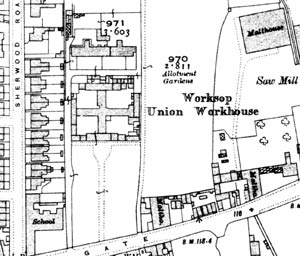
Worksop Union Workhouse as shown on the 25" to one mile Ordnance Survey map of 1914.
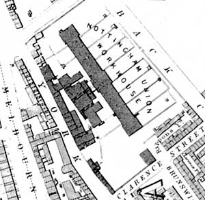
Plan of the Nottingham Union Workhouse built in 1840 as depicted on Salmon's map of Nottingham, 1861.
Ordnance Survey
Large scale Ordnance Survey maps from the late 19th and early 20th centuries show workhouses and their environment in great detail:
- 1:2500 (25” to the mile) and 1:10560 (6” to the mile) published in 1884 (1st revision in 1898; 2nd revision in 1916)
- 1:500 (10 feet to the mile) published 1884, cover urban areas only
Consult copies at Local Studies Libraries and Nottinghamshire Archives.
The British History Online website hosts a complete set of 6” maps for the county with the advantage that the original sheet numbers are used: helpful if you need to request the maps at a local studies library or Nottinghamshire Archives:
Other large scale nineteenth century maps exist: in particular Edward Salmon's Plan of the Town of Nottingham and its Environs, published in 1861. A reprint is available from Nottingham Civic Society.
Workhouse plans
Nottinghamshire Archives holds plans of the following workhouses:
- Basford (1913-1927)
- Mansfield (1908-1924)
- Newark (1915-1930)
- Southwell (c.1930)
- Worksop (c.1930)