
 |
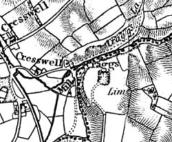
Extract showing Cresswell Crags from Sanderson's "Map of the Country Twenty Miles Round Mansfield" published in 1835. |
Cartographic
Printed
Early Ordnance Survey maps show the site before the sewage works and road. These can be purchased through www.ordnancesurvey.co.uk or www.old-maps.co.uk or seen in local studies libraries.
Manuscript
There is a wealth of manuscript evidence in the archaeological holdings in museums. Details can be found on www.creswell-crags.org.uk/Books_and_links/Resource_map/index.html.