
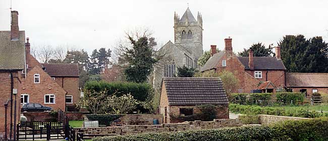
Laxton (photograph: A Nicholson, 1998).
Despite the growing urban sprawl of Greater Nottingham and the damaged post-industrial landscape of the former coalmining districts of western Nottinghamshire, the county is predominantly rural and the warm red brick and pantile-roofed village and surrounding farmsteads are characteristic features of the county’s landscape.
It is still a persistent view that rural life has been stable, conservative and unchanging. However, this has never been true: “settlements, like the men who live in them are mortal.” Villages were created and have evolved because of a particular combination of geographical, commercial, economic, social and seignurial factors. It is a story of fluctuating expansion, decline and movement.

Nottinghamshire parishes and townships, c.1835. Click on the image for a downloadable A4-sized PDF version.
Research suggests that many villages in Nottinghamshire have changed their layout, moved site, shrunk in size or become deserted. East Stoke, for example, has migrated away from near the medieval church to alongside the Fosse Way. The estate villages of Winkburn, Ossington, and Strelley were re-planned by removing houses from the vicinity of the hall to afford the landowner a greater degree of privacy. An excellent example of complete desertion is West Burton which was a village of 12 households with a church in 1750 but by the early 20th century the church had been demolished and the village reduced to grass-covered house platforms and sunken holloways, the result of rack-renting in the early 19th century which drove the tenants out. However, virtual extinction can be followed by a reversal in fortune: the population of Stanton-on-the-Wolds had shrunk to 30 by the end of the 17th century but its proximity to Nottingham has led to much new housing and it is now a thriving and expanding village of over 500 inhabitants.
In contrast, other villages have grown considerably, usually the result of industrial developments or the proximity to a major conurbation such as Nottingham. The coal mining industry has had a dramatic effect on settlements in the west of the county: the medieval villages of Bilsthorpe, Ollerton, Blidworth, Clipstone, Mansfield Woodhouse, Brinsley, Selston, Eastwood and Harworth, among others, grew rapidly in the early 20th century to accommodate an influx of mine workers. Other villages such as Ruddington, Keyworth, Gedling and Arnold have expanded dramatically as satellite settlements serving the growing city of Nottingham.
Settlement plans and patterns
Very little research has been published on settlement patterns and settlement plans in Nottinghamshire. No one has yet undertaken a study of village plans in the county using a classification scheme such as that devised by B K Roberts; however, a rare example is an article on the settlement morphology of Laxton which concludes that the village was a regularly planned settlement, the result of the landlord’s changing fortunes.
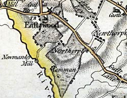 Eastwood as depicted on John Chapman's map of Nottinghamshire, published
in 1774. The village developed around the western edge of a large area
of common land
Eastwood as depicted on John Chapman's map of Nottinghamshire, published
in 1774. The village developed around the western edge of a large area
of common landEven the most cursory glance at early 19th century maps of Nottinghamshire will show the rich variety of village plans in the county. Large villages like East Bridgford and East Markham have polyfocal layouts, whereas smaller settlements such as Linby and Halloughton have simple row plans. Car Colston, Wellow and Blyth all have greens at the centre of the settlement and on the western fringe of the county, villages like Eastwood and Selston originally developed around the edge of extensive common land.
Early 19th century maps also reveal differing settlement patterns across the county, reflecting the broad landscape regions with differing settlement and landscape characteristics. The west of Nottinghamshire is marked by large historic parishes like Blyth, Worksop, Greasley, and Selston that cover a mixture of nucleated villages and dispersed hamlets and farmsteads. For example, in 1832 Greasley was a parish of over 6,000 acres and included the villages and hamlets of Brinsley, Kimberley, Moorgreen, Newthorpe, Watnall Cantelupe, Watnall Chaworth, the “scattered dwellings” of Hill Top, Beauvale/Beggarlee, Bogend and the detached hamlet of Hempshill.
The Trent Valley on the eastern side of Nottinghamshire, on the other hand, is characterised by large nucleated villages with their associated farmsteads. The Vale of Belvoir, to the south of Newark, is also distinguished by nucleated settlements but they tend to be relatively small and are located within small parishes.
The village community
Population structure (age and sex breakdowns, life expectancy, family size, marriageable age, infant mortality etc.) can be estimated from parish records and more confidently from the 19th century Census. Simple analysis of the registers can be taken a stage further by using the family reconstruction approach which aims to compile biographical histories of each individual in the community. This research can be augmented by material from other contemporary sources such as estate records (e.g. rentals, accounts and surveys), local government archives (e.g. poor law accounts) or non-documentary sources such as monumental inscriptions.
Other classes of archives such as manorial court rolls, church court records, household wills and inventories and quarter sessions records can offer insights into life within the community. For example, recent work on the archives of the Archdeaconry of Nottingham has highlighted their usefulness for reconstructing life in 16th or 17th century villages, since there is much evidence of trades, customs, agriculture, prevalence of servants, illegitimate children to be found in the churchwardens’ presentment bills sent to the Archdeaconry Court.
![]()
![]()