
Cartographic
Printed
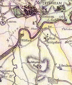 Detail of John Chapman's map of Nottinghamshire (1774)
Printed maps are available at Nottinghamshire Archives, Nottingham Local Studies Library and West Bridgford Library. The Nottinghamshire Insight Mapping web site has a selection of historical ordnance survey maps that can be viewed in an overlay to show how the use of land has evolved. Cassini maps also has historical maps for sale.
John Chapman’s map of 1774 shows St Giles’ church and a cluster of nearby houses forming the village of West Bridgford – as shown in the image.
1835 George Sanderson’s Map of the Country 20 Miles Round Mansfield.
The First Edition of the 6 inch : 1 mile Ordnance Survey maps shows the first houses to be built as West Bridgford embarked upon its transformation from a village to a town. There are also 25 inch : 1 mile maps.
Manuscript
The 1838 tithe map of West Bridgford, together with the apportionment, is held by the National Archives.
Manuscript maps can be found at the Nottinghamshire Archives and the University of Nottingham Manuscripts and Special Collections of the sale plans from the end of the nineteenth century of the Musters Estate in West Bridgford and of the Lady Bay estate.