
Cartographic
Printed
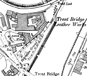
Turney Bros Ltd depicted on the 1899 25" to the mile Ordnance Survey map of Nottingham.
Ordnance Survey maps
Large scale Ordnance Survey maps from the late 19th and early 20th centuries show buildings and sites related to the leather industry in great detail:
- 1:2500 (25” to the mile) and 1:10560 (6” to the mile) covering the whole county published from the 1880s
- 1:500 (10 feet to the mile) of urban areas from the 1880s
These maps can be consulted at Nottinghamshire Archives or the local studies sections of Nottingham Central Library and the larger town libraries in the county.
See the Old Maps website for a good range of 1:2500 and 1:10560 OS maps.
Nottinghamshire Archives
- DD/GOAD Goad fire insurance maps of Nottingham, 1886-1962
- DD.TY XBM 7/1-3L
- XBM 23/1-2L