
Cartographic
George Sanderson’s map, Twenty miles around Mansfield, originally published in 1835, covers most of Nottinghamshire at a useful scale of 2¼ inches to 1 mile and depicts early railways connecting collieries with canal wharves in the Erewash valley, the route of Mansfield & Pinxton Railway and also the proposed route of the Midland Railway along the valley. A reproduction was been published by Nottinghamshire and Derbyshire Library Services in 2001
Ordnance Survey
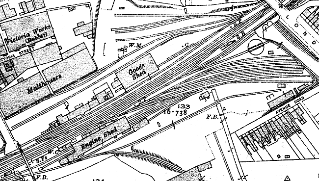
The Great Central engine and goods sheds and sidings at Thrumpton Lane, Retford as depicted on the 25" to a mile Ordnance Survey map (1920).
Large scale Ordnance Survey maps from the late 19th and early 20th centuries show the railways and associated structures in great detail:
- 1:2500 (25” to the mile) and 1:10560 (6” to the mile) covering the whole county published from the 1880s
- 1:500 (10 feet to the mile) of urban areas from the 1880s
Smaller scale maps depict the rail networks and stations at various dates throughout the 19th and 20th centuries:
- One-inch maps (1:63350) date from the 1840s (see the Vision of Britain website for online versions of these maps)
- Quarter-Inch maps date from the 1890s
These maps can be consulted at Nottinghamshire Archives or the local studies sections of Nottingham Central Library and the larger town libraries in the county.
National Rail Museum and Archive
“There are several hundred railway maps and plans in the Archives. These range from maps showing the proposed routes of early lines, through several examples of early published maps such as Bradshaw’s, Wyld’s and Cheffins’, through to the series of maps published by The Railway Clearing House, company and network maps, and examples of modern maps showing the boundaries of train operating companies. There are also some examples of signalling and station plans.”
The National Archives
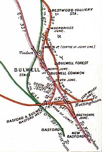
Railway Clearing House railway junction diagram of the Basford and Bulwell area north of Nottingham in 1913.
A wide range of maps and plans are held by TNA, including:
- Two-chain surveys of routes
- Gradient diagrams
- Distance or mileage diagrams
- Station plans
- Siding diagrams
- Railway Clearing House plans
- Technical drawings of buildings, bridges and viaducts, lineside buildings, signalling plans, locomotives and rolling stock
- “RAIL 1029-1037 (formerly MPS 1-8 and MPS Y) are nine series that have been assigned to railway maps and plans and they can be searched by consulting the catalogue or the series lists. Many other maps, plans and diagrams are to be found scattered throughout the RAIL series. Some of the plans, which accompanied private Acts of Parliament can be found in RAIL 1071 , but a full set is held in the Parliamentary Archives. MT 54 holds light railway plans and War Office maps and plans depicting railways can be found in WO 153 , WO 297 and WO 298 , WO 300 , WO 301 , WO 302 and WO 303 . Some civil engineering plans and drawings for the construction of railway lines, stations and depots can also be found at The National Archives, particularly in MT 8 and MT 91 .”
Further information is available on the National Archives online catalogue.
Nottinghamshire Archives
Search for records using Access 2 Archives and the Nawcat online catalogue. Holdings include:
- Deposited plans of railway schemes (1813-1963) [C/DP/R]
- Plans of Great Northern Railway works around Newark (1850-1904) [DD/T/206]
The Last Main Line (The Great Central Railway)
The NOF-funded website makes available images of original plans for the section Great Central Railway London Extension between Annesley Junction and Rugby.