
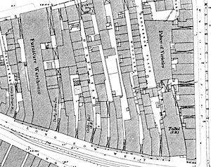
Detail of the 1882 Ordnance Survey 1:500 map showing the site of Pearson's shop on Long Row West.
Cartographic
Ordnance Survey maps
Large scale Ordnance Survey maps from the late 19th century to the present day show Nottingham in great detail:
- 1:2500 (25” to the mile) and 1:10560 (6” to the mile) published in 1884 (1st revision in 1898; 2nd revision in 1916)
- 1:500 (10 feet to the mile) published 1882
Two online sources of historical Ordnance Survey maps of Nottingham are:
Goad Insurance maps
Charles E. Goad was a London-based firm of surveyors who mapped the major towns and cities to help fire insurance companies assess potential liabilities. The maps were produced at a scale of 1" to 40 feet and Nottinghamshire Archives hold maps for Nottingham for 1886-93, 1922, 1934, 1946 and 1962.
The 1886 edition of the Goad insurance plans for Nottingham are available online: