
Cartographic
Printed
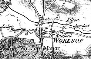
Extract from Chapman's map of Nottinghamshire.
John Chapman’s map of Nottinghamshire (1774) is the earliest printed map at a sufficiently useful scale (1 statute mile to one inch) to provide basic information on town and village layout and the existence of landscape features such as roads, parkland and mills. A facsimile version was published by Nottinghamshire County Council in 2003.
George Sanderson’s map, Twenty miles around Mansfield, originally published in 1835, covers most of Nottinghamshire at a useful scale of 2¼ inches to 1 mile (showing fields, individual buildings, roads, industrial sites, parish and township boundaries, etc) and a reproduction has been published by Nottinghamshire and Derbyshire Library Services.
Ordnance Survey
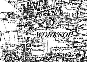
Extract from Ordnance Survey 6" to 1 mile map of 1887.
Large scale Ordnance Survey maps from the late 19th and early 20th centuries show the town in great detail:
- 1:2500 (25” to the mile) and 1:10560 (6” to the mile) published in 1884 (1st revision in 1898; 2nd revision in 1915)
- 1:500 (10 feet to the mile) published 1884 in 10 sheets
These maps can be consulted at Nottinghamshire Archives or the local studies sections at Nottingham Central Library or Worksop Library.
Nottinghamshire Archives
- Printed coloured plan of the Worksop Manor Estate, Nottinghamshire; 1838 (“Plan shows farmhouses, plantations, trees, roads, tracks, and fields; titheable land is indicated using an accompanying key; the adjacent areas of Clumber Park, Welbeck Park, Anston, Gateford, Scofton, Osberton and Whitwell are shown.” [Ne P/7]
Manuscript
Nottinghamshire Archives
- A map of Worksope Manor with the town of Worksope and parts adjoining ... the estate of his grace the Duke of Norfolk, 1763 [MP/WS 3L/1-6]
- A map of Worksop Manor together with the town of Worksop and parts adjoining ... belonging to the most Noble Edward Duke of Norfolk, 1775 [MP/WS 2 L/1-6]
- Local Board of Health plans (10 feet to one mile) showing industrial buildings, pumps and lavatories etc c.l858 [MP/WS 2R]
- Corn rents maps (4), cl813 [PR 22,786]
- Tithe maps, 1848 (AT 152/1C)
- Enclosure maps (3), 1817 EA 145/2/1-3
- Worksop to West Retford turnpike road, 1821 SO/TT 1/2
- Worksop to Mansfield turnpike road, 1821 SO/TT 1/3
- Railway plans: various, 1844-1914 C/QDP/R
Bassetlaw Museum
- Worksop Local Health Board/Urban District/Borough building control plans of individual properties, 1857-89, 1897-1950
Maps held elsewhere
- Worksop Manor, early 17th century [Arundel Castle: H2/47]
- A general plan of the park and gardens at Worksop Manour the seat of his grace the Duke of Norfolk, c.1750 [Cumbria Record Office: D/Lons/L/Plans/Worksop]
- A map of the manor of Shireoaks, 1790 [Sheffield City Archives: LD 1086 R]
- A map of the manor and lordship of Gateford, 1793 [Privately held]