
Cartographic
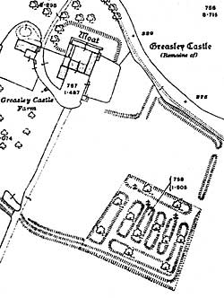
Greasley Castle depicted on the 25" to 1 mile Ordnance Survey map (1915).
Printed
- The Rampton Tapestry Map, (see Muriel Clayton, 'A tapestry map of Nottinghamshire', Transactions of the Thoroton Society, 38, 1934)
- Ordnance Survey maps available from Local Studies Libraries
- Enclosure Maps and Tithe Awards available from the Nottinghamshire Archives Office
Manuscript
There are no major surviving medieval manuscripts depicting the castles of Nottinghamshire. Nottingham Castle and castle rock do appear as part of the initial letter illumination in a 14th century manuscript but this is a rare example. Fortifications in general, however, do make popular subjects for illustration. A useful collection of examples can be found in Pamela Porter’s Medieval Warfare in Manuscripts, 2000.