
Graphic
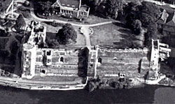
Aerial view of Newark Castle, c.1940.
Photographic
Aerial photographs are available for all sites. These can be purchased or accessed from many different providers and it may be helpful to consult the list of sources available online at:
Nottinghamshire County Council Environment Department has a set of colour vertical photographs whilst some black and white oblique shots are held by the Trent and Peak Archaeological Unit. The National Monuments Record at Swindon has a full collection of copy prints. Contact them at the NMR Enquiry & Research Services: www.english-heritage.org.uk
Aerial photographs also appear in a number of relevant publications, including:
- R.Allen Brown, Castles from the Air, Cambridge University Press, 1989
- Castles and Cathedrals, Harper Collins/Get Mapping, 2001
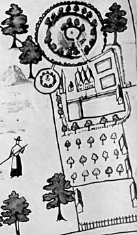
Laxton Castle as depicted on Mark Pierce's map of 1635.
Artistic
From the 17th century we have two fine examples of cartographic illustration.
The Rampton Tapestry Map (1632) uses symbols to represent the towns and villages of the county – that for Greasley is a gatehouse feature that may or may not be an accurate representation of the castle.
The Mark Pierce Map of Laxton (1635) was produced to accompany an estate terrier. It has an excellent illustration of the castle (see C.S and C.S.Orwin, The Open Fields, 1938). There is a colour copy in the Visitor's Centre at Laxton.